When Sea Level Change is NOT Sea Level Change
December 12, 2011
by Dr. Timothy Ball
Science&Public Policy
December 12, 2011

Figure 1. Click to enlarge image
Many claim sea level is rising because of global warming and point to changes along the Gulf of Mexico coast. Sea level has risen since the end of the last Ice Age (Figure 1), but it has slowed dramatically in the last few hundred years. However, shoreline change is not just a function of water level change. Misdirection using fear and misinformation divert from and hinder human ability to adapt to an ever changing world.
When you visit a shoreline over time and the water line changes, it is natural to assume, because of education and reason, it is the water level that has changed. This may be the case, and if so, it is called eustasy. However, it is also possible that the land is rising or falling in a process called isostasy. There are ways to determine which change is going on, but not by observation. This difficulty often results in people attributing a sea level rise incorrectly as evidence of global warming when it is the land that is sinking. This misattribution occurs most often on the Gulf of Mexico coast of the southern US.
The continents are formed of Sial, an abbreviation of silica and aluminum. This makes the continental crust lighter than the underlying oceanic crust, which is primarily silica and magnesium, Sima. The latter is rich in iron and more dense than the continental crust. It means the continents effectively ‘float’ on the underlying oceanic crust, which in turn sits on the fluid material of the mantle. The continents rise and fall with tidal frequency from the pull of the moon.
Figure 2 compares North America 20,000 years ago with today. The blue on the left map shows the extent of the ice, which was greater in area than Antarctica and 3000 m (10,000 feet) deep in the dark blue region centered on Hudson Bay. Notice the difference in coastline as sea level was approximately 140 m (460 feet) lower.

Figure 2. Click to enlarge image
Consider the weight of the ice sitting on a floating continent. Figure 3 is a cross section along the line AB on Figure 2 illustrating how the ice deforms the land.
When winter snow survived the summer melt high in the Torngat Mountains of Labrador, layers built until a continental glacier was formed. The ice sheet centre spread west as the snow was heavier in the prevailing westerlies. At the peak of glaciation, the thickest ice lay over Hudson Bay.
It is easier to think of the continent as a sponge floating in water. Place a heavy metal disc on the sponge and two things happen. The sponge is depressed as you can see at A on Figure 3. This is called crustal deformation. However, the weight of the ice also pushed the continent down into the underlying mantle at B. The southern end of the continent at C was pushed upward. The pivotal line for rotation of the continent is along the southern edge of the ice; and some associate the New Madrid Fault zone and increased earthquake activity with this line.
The line of zero depression, or hinge line, due to the combination of crustal deformation and isostasy is along the southern edge of the

Figure 3. Click to enlarge image
ice. As the ice began to melt, the land started to rebound, just as the sponge recovers shape when the metal disc is removed.
In North America, a massive proglacial lake formed along the southern edge of the ice sheet. Lake Agassiz is reported to be the largest freshwater lake ever formed (Figure 4). Lake Winnipeg, which is the 13th largest lake in the world by area, is just a remnant of Agassiz.
It is outflow from Lake Agassiz that became part of another global warming scare when it was theorized to have caused dramatic changes in the North Atlantic Thermohaline current and subsequent climate change.
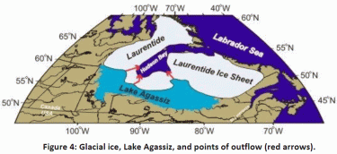
Figure 4. Click to enlarge image
Beaches formed along the shores of Lake Agassiz, especially in western Manioba, were obviously level. As the land rebounded they were distorted so a survey along the highest and longest Campbell Beach shows the North end is now some 935 feet higher than the South end. It is one measure of the amount of rebound. It was surprisingly fast immediately after retreat of the ice, estimated at 10 m (33 feet) to 12 m (39 feet) per century. It is still a rapid 1.3m (4.3 feet) per century. This is a combination of recovery of crustal deformation, but mostly the continent rebalancing itself. As this happens the land rises and sea level appears to drop along the Arctic coast, but land sinks and sea level appears to rise along the Gulf of Mexico.
Isostatic adjustment will continue in North America as estimates based on depth of ice indicate total depression at 400 m (1300 feet). This means approximately 111 m (365 feet) of rebound will occur. Both sea level rise due to eustasy and land sinking due to isostasy will continue along the Gulf of Mexico. The good news is both are consequences of buildup of massive glaciers on the continent and consequent sea level drop to the peak of the Wisconsin ice advance 20,000 years ago. Now, as we appear to reach the peak of the Interglacial, the melt of the glaciers on the continent and resulting sea level rise are slowing. Rate of these events are known. Now we
must stop the exploitation of fear using false information so we can prepare appropriately for a constantly changing world and climate.